
File:Argentina topo blank.jpg

Size of this preview: ༤༤༥ × ༥༩༩ pixels. Other resolutions: ༡༧༨ × ༢༤༠ pixels | ༣༥༧ × ༤༨༠ pixels | ༥༧༡ × ༧༦༨ pixels | ༧༦༡ × ༡,༠༢༤ pixels | ༡,༦༠༠ × ༢,༡༥༣ pixels.
ཧུམ་ཆ་གང་། (༡,༦༠༠ × ༢,༡༥༣ པིག་སེལ་ ཡིག་སྣོད་ཀྱི་ཚད་: ༥༦༥ KB མའིམ་དབྱེ་བ་: image/jpeg)
| Description |
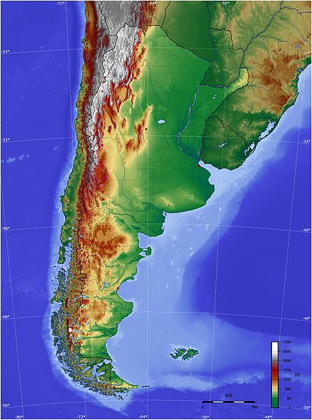
Español: Mapa de Argentina con su relieve
English: Map of Argentina with its terrain levels |
||||||||||
| Date | 9/06/2006 | ||||||||||
| Source | See below | ||||||||||
| Author | Captain Blood | ||||||||||
| Permission (Reusing this file) |
|

ཡིག་སྣོད་སྤྱོད་ཤུལ།
ཡིག་སྣོད་འདི་ དེ་བསྒང་སྟོན་དོ་བཟུམ་སྦེ་ བལྟ་ནི་གི་དོན་ལུ་ ཚེས་གྲངས་/ཆུ་ཚོད་གུ་ ཨེབ་གཏང་འབད།
| ཚེས་གྲངས་/ཆུ་ཚོད། | Thumbnail | རྒྱ་ཚད་ | ལག་ལེན་པ། | བསམ་བཀོད། | |
|---|---|---|---|---|---|
| ད་ལྟོ། | ༢༡:༤༥, ༡༣ སྤྱི་ཟླ་ལྔ་པ། ༢༠༠༩ | | ༡,༦༠༠ × ༢,༡༥༣ (༥༦༥ KB) | Keysanger | reverted. (Deleted yellow line in the Straits of Magellan, added the definitive end of the controversial border at the Beagle Channel and marked with a white box the (last) undefined border zone as agreed both countries.) |
| ༠༤:༡༠, ༥ སྤྱི་ཟླ་ལྔ་པ། ༢༠༠༩ |  | ༡,༦༠༠ × ༢,༡༥༣ (༨༦༧ KB) | Dexxter | Reverted to version as of 18:57, 9 June 2006 | |
| ༢༠:༡༣, ༤ སྤྱི་ཟླ་དྲུག་པ། ༢༠༠༨ |  | ༡,༦༠༠ × ༢,༡༥༣ (༥༦༥ KB) | Keysanger | Argentina topo deleted yellow line in the Straits of Magellan, added the definitive end of the controversial border at the Beagle Channel and marked with a white box the (last) undefined border zone as agreed both countries. [[Category:[[Category:Topograp | |
| ༡༨:༥༧, ༩ སྤྱི་ཟླ་དྲུག་པ། ༢༠༠༦ |  | ༡,༦༠༠ × ༢,༡༥༣ (༨༦༧ KB) | Captain Blood~commonswiki | {{Bild-GFDL-GMT}} |
འབྲེལ་ལམ།
འོག་གི་ཤོག་ལེབ་ཚུ་ ཡིག་སྣོད་འདི་དང་འབྲེལ་བ་འདུག:
Global file usage
The following other wikis use this file:
- Usage on bg.wikipedia.org
- Usage on bn.wikipedia.org
- Usage on ca.wikipedia.org
- Usage on ckb.wikipedia.org
- Usage on ee.wikipedia.org
- Usage on el.wikipedia.org
- Usage on en.wikipedia.org
- Usage on eo.wikipedia.org
- Usage on es.wikipedia.org
- Usage on eu.wikipedia.org
- Usage on fa.wikipedia.org
- Usage on fi.wikipedia.org
- Usage on fr.wikipedia.org
- Usage on gcr.wikipedia.org
- Usage on hu.wikipedia.org
- Usage on hy.wikipedia.org
- Usage on incubator.wikimedia.org
- Usage on io.wikipedia.org
- Usage on it.wikipedia.org
- Usage on ja.wikipedia.org
- Usage on ka.wikipedia.org
- Usage on kbd.wikipedia.org
- Usage on ko.wikipedia.org
- Usage on ml.wikipedia.org
- Usage on ms.wikipedia.org
- Usage on mt.wikipedia.org
- Usage on pl.wikipedia.org
- Usage on pt.wikipedia.org
View more global usage of this file.