
File:Amazon.A2002182.1405.1km.jpg
Size of this preview: ༧༧༡ × ༦༠༠ pixels. Other resolutions: ༣༠༩ × ༢༤༠ pixels | ༦༡༧ × ༤༨༠ pixels | ༩༨༨ × ༧༦༨ pixels | ༡,༢༨༠ × ༩༩༦ pixels | ༡,༨༠༠ × ༡,༤༠༠ pixels.
ཧུམ་ཆ་གང་། (༡,༨༠༠ × ༡,༤༠༠ པིག་སེལ་ ཡིག་སྣོད་ཀྱི་ཚད་: ༡.༧༨ MB མའིམ་དབྱེ་བ་: image/jpeg)
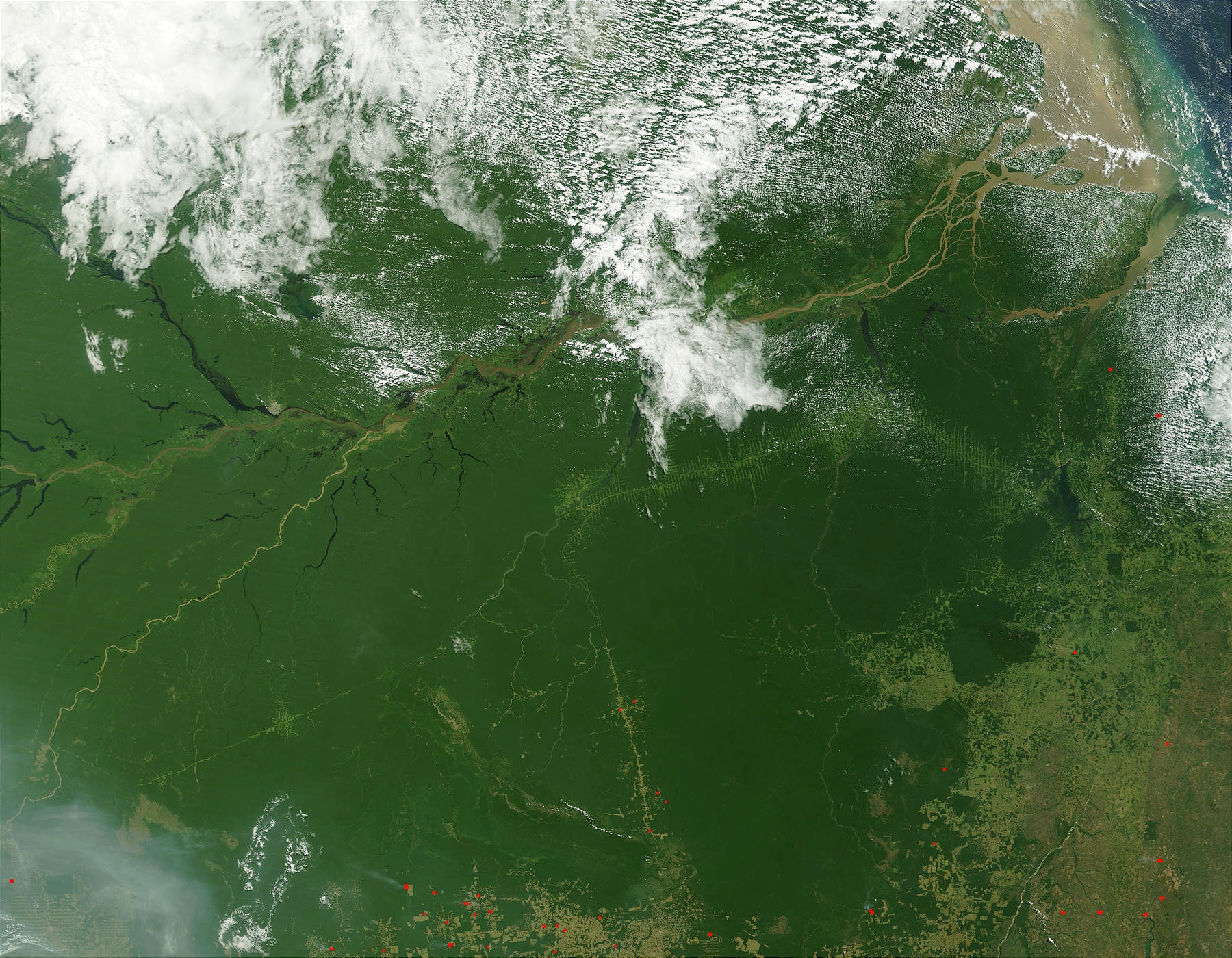
Imagen de la Selva Amazónica tomada desde satélite. The Amazon Rainforest (NASA).
Fuente: http://visibleearth.nasa.gov/view_rec.php?vev1id=14697 archive copy at the Wayback Machine Credit Jacques Descloitres, MODIS Land Rapid Response Team, NASA/GSFC - The Amazon, Brazil
Summary
- "The Amazon Rainforest appears to have been colored solid with a green crayon in the western portion of this true-color image of northern Brazil captured by the Moderate Resolution Imaging Spectroradiometer (MODIS) on July 1, 2002. The Amazon River flows into the scene at the center left edge, a meandering brown line that widens as first the Rio Negro joins it from the north and then the Madeira joins it from the south. The Amazon flows eastward, eventually spilling its brownish, sediment-laden waters out into the Atlantic Ocean.
- At bottom right and bottom center, deforestation and cultivation are evident by the regular, rectangular shapes that delineate plots. Fire is a common means of clearing land and this type of slash-and-burn agriculture is having a devastating impact on plant and animal communities as well as people who are native to the forests. MODIS has detected numerous fires (red dots) and thick smoke is visible at bottom left.
- Once an impassable jungle, the Amazon is now crossed by at least a few roads, which make pale green lines across the dense forest. Cross hairs extending outward from the road may be a harbinger of future development.
- In the false-color image, dense vegetation is deep orange-gold, while areas that have been deforested are paler yellow. Are that appear pale green or blueish green are naturally occurring areas of less dense vegetation. Water is dark blue or black."
| This file is in the public domain in the United States because it was solely created by NASA. NASA copyright policy states that "NASA material is not protected by copyright unless noted". (See Template:PD-USGov, NASA copyright policy page or JPL Image Use Policy.) | ||
 |
Warnings:
|
ཡིག་སྣོད་སྤྱོད་ཤུལ།
ཡིག་སྣོད་འདི་ དེ་བསྒང་སྟོན་དོ་བཟུམ་སྦེ་ བལྟ་ནི་གི་དོན་ལུ་ ཚེས་གྲངས་/ཆུ་ཚོད་གུ་ ཨེབ་གཏང་འབད།
| ཚེས་གྲངས་/ཆུ་ཚོད། | Thumbnail | རྒྱ་ཚད་ | ལག་ལེན་པ། | བསམ་བཀོད། | |
|---|---|---|---|---|---|
| ད་ལྟོ། | ༠༠:༠༠, ༡༥ སྤྱི་ཟླ་དྲུག་པ། ༢༠༠༥ | | ༡,༨༠༠ × ༡,༤༠༠ (༡.༧༨ MB) | Tano4595 | Imagen de la Selva Amazónica tomada desde satélite. The Amazon Rainforest (NASA). |
འབྲེལ་ལམ།
འོག་གི་ཤོག་ལེབ་ཚུ་ ཡིག་སྣོད་འདི་དང་འབྲེལ་བ་འདུག:
Global file usage
The following other wikis use this file:
- Usage on bs.wikipedia.org
- Usage on de.wikipedia.org
- Usage on en.wikipedia.org
- Usage on eo.wikipedia.org
- Usage on es.wikipedia.org
- Usage on et.wikipedia.org
- Usage on eu.wikipedia.org
- Usage on fi.wikipedia.org
- Usage on fr.wikipedia.org
- Usage on gl.wikipedia.org
- Usage on he.wikipedia.org
- Usage on lt.wikipedia.org
- Usage on no.wikipedia.org
- Usage on pl.wiktionary.org
- Usage on pt.wikipedia.org
- Usage on ro.wikipedia.org
- Usage on ru.wikipedia.org
- Usage on sh.wikipedia.org
- Usage on sv.wikipedia.org
- Usage on uk.wikipedia.org
- Usage on vi.wikipedia.org
- Usage on vi.wiktionary.org